|
Day
8: September 13
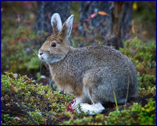
It was raining when we got up in the morning. A
white-footed bunny rabbit was hopping around among the cabins; I
stalked him to get a photo. We
later learned he was a snowshoe hare, and his white feet marked the
beginning of his coat turning pure white for the winter.
We had delicious non-sourdough wild blueberry pancakes for
breakfast at the café.
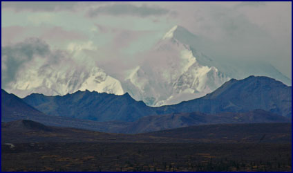
The clouds started to lift a little, showing occasional
patches of blue sky. We
drove up the
Denali
Park
road once more; there wasn’t much wildlife about, but we got a
view of
Mt.
McKinley
again, bright in the morning light.
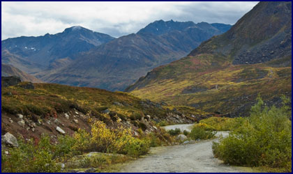
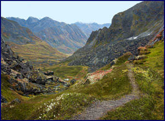
Our plan for the day was to hike
Mt.
Healy
, a sizeable mountain right on the edge of the
Denali
National Park
. This hike was listed
in our guidebook and had also been recommended by several local
people, but rather than the more conventional access from the park
entrance, we were taking the back route up, from Bison’s Gulch.
Our directions said to take the
trail up from the little car park by the road, but we were
immediately faced with a choice of three trails.
We chose the left hand path, which seemed the clearest; it
wound through dense willow thickets before merging with the middle
trail and coming out alongside the creek.
We surmised that the trail would follow the creekbed for a
while before climbing up to the right to traverse the top of the
ridge, so we should be on track.
But the path out of the creek never appeared, and by the time
we figured out that we weren’t really on the
Mt.
Healy
trail at all but instead just scrambling up the stream bed of
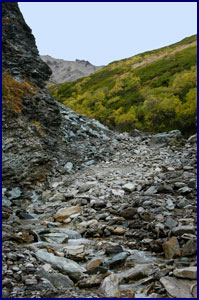
Bison’s Gulch, we had come too far to want to turn around.
We carried on up the creek (pun intended). If
we were looking for the ‘road less traveled’ then we had
certainly succeeded; we didn’t see another soul for the entire
hike, nor indeed, any sign that anyone had ever come this way
before.
Though the creek itself was small,
the rocky streambed was fairly wide; we had no doubt that during
spring snowmelt a raging torrent must come roaring down through the
gulch. We clambered up
over the rocks, crossing the stream many times.
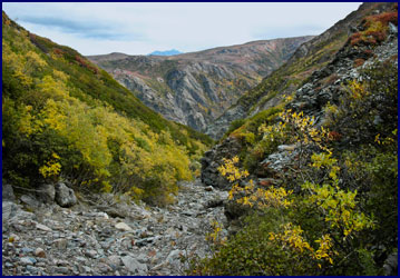
Our progress was slow, but we kept moving steadily forward,
ever climbing. Every so
often we paused and looked back; we could catch glimpses of the
valley we had left below, and we were amazed by how far we had come.
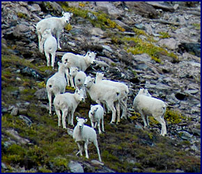
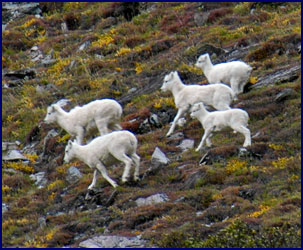
Ahead we could see steep mountainsides towering above the
creek bed, and Dall sheep high on the slopes.
We climbed for what seemed like
forever. The higher we
went the steeper our path became.
In places the gorge narrowed and the walls were sheer.
We scrambled up the watercourse, the rocks wet and slippery
in places, and often unstable under our feet.
As we gained altitude the going was much rougher, and the
wind became very strong. Looking
up from the gulch, we saw that we were much closer to the sheep now.
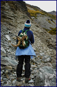
We came across a pair of horns from
a Dall sheep; they seemed to have been left there just for us to
find. How long had they
lain there by the creek, waiting for some passerby?
We never did find out how the horns came to be so
conveniently in our path, but we decided they represented “the
spirit of the ram” and would protect us from harm.
We took them with us, Jineen carrying them on the back of her
pack.
The
creek narrowed as we followed it to its source high on the
mountainside. We were
level with the sheep that grazed on the steep slope on the other
side of a ravine. The
streambed split; exploring the right hand side and finding it
impassable, we took the left fork and continued upward.
Soon we had climbed well above the
start of the creek, and there was no longer a clear route to follow.
We tried to pick the path of least resistance, but our course
was becoming more and more difficult.
We weren’t sure if it was possible to get to the top, but
having come so far, we were determined to give it our best try.
"Because it's there" said George Mallory about
climbing Everest. Whatever
was he thinking!?!
The final slope was seriously steep.
We scrambled up over the rocks and loose scree, using our
hands as well as our feet, our hearts pounding and our legs
trembling with fatigue. We
were barely able to keep our footing, and we worried about how we
would get back down. The
wind was gusting so strong that we feared it would blow us off the
mountain. We were now
looking down at the sheep.
The last fifty yards about killed us.
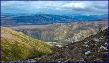
Finally we made it to the top on legs of rubber.
We came out on an open expanse on the ridge, where we were
rewarded for our effort with an amazing panoramic view.
We sat on the shoulder of the mountain and looked out over
the valley lying serene below us, and the majestic mountains rising
beyond. It was an almost
spiritual experience. We
looked down on creation. We
had climbed
Mt.
Healy
by a unique route, and we wondered how many people before us had
ever come that same way, and if any of them had ever stood just
where we stood and looked out on the very same view.
The wind was relentless and the air was cold, so we
couldn’t linger at the top for too long.
We were apprehensive about making our way down that final
steep slope, but it proved to be easier than we thought;
we carefully traversed back and forth until we were on less
treacherous ground. Presently
we came to the source of the stream and started following the
creekbed back down. We
surprised a pair of ptarmigan, their mottled feathers in the process
of changing from grey to white, affording them a perfect camouflage
among the rocks. We
found an indented place under a cliff that was somewhat sheltered
from the wind, and had a brief picnic of bread and cheese from our
packs.
As we made our way down the creekbed, we saw that the Dall
sheep had moved lower, nearer to the gully - we figured they sensed
our “spirit of the ram” protection, and were therefore drawn to
us. We watched them for
a while, until they decided we were unacceptably close and fled
across the steep mountainside. We
were keeping a keen eye out for bear signs; we found none, but we
did see a wolf track in the wet sand alongside the creek.
Going up the mountain requires more
energy and work, but going down can be harder on certain leg
muscles. Our legs were
definitely trembling with fatigue well before we finished the long
downhill scramble through the gulch.
Eventually we made it to the bottom, exhausted, six hours
after we had set out - four hours to get to the top and two to come
down. We sat in our car
at the base of the mountain with a real feeling of accomplishment,
looking up at the summit of
Mt.
Healy
far above us, and marveling at the climb we had made.
We grabbed a quick dinner at the Creekside Café, and then
drove 90 miles south to our accommodations for the night, Mary’s
McKinley View Lodge. It
was founded by Mary Carey, a locally famous woman who homesteaded
the land in the early 1960s. She
was an accomplished journalist and author who led a very adventurous
life, which is now being turned into a movie.
I later read one of her books, ‘
Alaska
, Not for a Woman,’ and really enjoyed learning about her history.
We were looking forward to a night at Mary’s lodge, which
is now owned and run by her daughter Jean.
It was late when we arrived, and we
were tired. The lodge
did not at all match the image we had of it in our minds.
The website had described it as a charming authentic Alaskan
Lodge with a homey atmosphere, and so it probably had been once, but
now it was run-down and shabby.
We were given directions
to our room. We got our
suitcases out of the car and lugged them through the rain and up the
front stairs, along a narrow cluttered hallway, and through some
sort of weird utility room. There
were boxes stacked in the hallways, and the laundry room looked
sinister. We continued
down some stairs, back outside, around a corner and up a cold wet
hallway - only to discover, when we finally found our room, that it
had not been cleaned or made up.
Retracing our steps back to the office, we told the owner
Jean about the condition of the room; she vehemently hissed “I’m
going to kill her!” We
hoped she was talking about the maid, and not us.
We were given the key to another
room. We followed the
route once more, this time dragging our luggage down yet another set
of steps to the basement level – where we found that the key would
not unlock the door to our new room.
This was getting ridiculous.
Back up the various stairs and
hallways again; this time we were helped by the guy who worked
there, Mary Carey’s grandson.
Muttering something about ‘this hellhole is going to the
dogs,’ he managed to wrestle open our door with a crowbar or
something, and suggested that we might not want to lock it again if
we didn’t want to be imprisoned forever.
Our room was kind of creepy, with
cement walls and ancient Venetian blinds that didn’t work.
The inn was founded in the early 1960s, and it seemed evident
that they had not changed the mattresses since then.
Because of the drive we had not yet had happy hour, so we
decided to partake there in the ambiance of our room.
We opened the bottle of Wild Rose Honey wine that we had
bought on the first day, the only actual Alaskan wine we had found.
It tasted awful, and after a few sips we pronounced it
undrinkable; we left the rest of the bottle for the maid who
hadn’t cleaned our room - we figured she deserved it.
Day
9: September 14
When we woke up in the morning it
was raining; what a surprise. This
was to be our last full day in
Alaska
; we would fly out the following evening.
We had breakfast at Mary’s cafe, which being a favorite
lunch stop for the tour buses, was very modern and nice, in stark
contrast with the lodging. Like
most of the places near
Denali
, they were getting ready to close for the winter; the following day
would be the last day of the season.
The ad in the Milepost for Mary’s
McKinley View Lodge said that there was a view of the famous peak
from every room, but this morning we could see nothing but clouds.
There was a huge picture window in the café to view
Mt.
McKinley
when it was visible, which we learned from our waitress was only
about 20 percent of the time. We
visited the gift shop, then donned our rain suits and set out to
look for bears.
We had hoped to hike on Kesugi Ridge, said to be a strenuous
but spectacular hike when the weather is good, with fabulous views
of
Mt.
McKinley
and the
Alaska Range
. But the dense clouds
and steady rain made it considerably less appealing, so we decided
to leave it for another trip. Instead,
we thought, this was the day to see bears.
We headed to Lower Troublesome Creek in search of them.
Troublesome Creek is notorious as an
area where bears are prevalent, and there were many cautionary signs
at the trailhead. In the
past the Park Service has closed off this area to hikers during
salmon spawning because of the danger from bears, but recently they
have discontinued this practice, and relied on just posting notices
reminding hikers of proper bear etiquette.
The advice we had heard most often was to make plenty of
noise while hiking; talk, wear bells, call out “Hello Mr. Bear”
at intervals - anything to avoid surprising a bear.
Apparently most bear attacks happen as a result of people
startling the bears; if they hear you coming they will move away and
avoid confrontation. But
of course the drawback to that, aside from feeling sort of stupid
calling out “Hello Mr. Bear” all the time, is that if you make
noise to give the bears fair warning, then you don’t actually get
to see them.
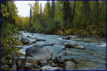
We hiked along the stream amid woods
and dense underbrush. Soon
we came to a spot where the trail led down to the side of the creek,
and we crossed to a little gravel bar island.
There we found bear tracks, the first we had seen while out
hiking alone. With
backward glances over our shoulders, we checked that our pepper
spray was within easy reach and proceeded cautiously.
Presently we came out of the woods
to where the stream joined a broad river.
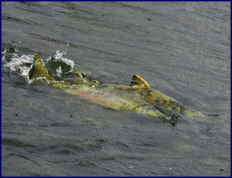
An eagle was sitting in a tree overlooking the water, and
hundreds of King salmon were struggling upstream to spawn.
The shoreline was covered with fresh bear tracks.
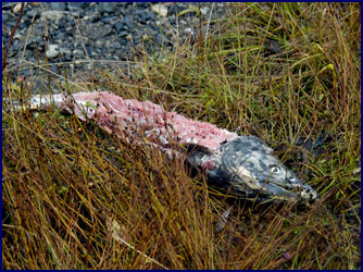
We saw several recently killed and half eaten salmon beside
the river; it appeared that the bears had breakfasted there, perhaps
only moments before. We
hoped that meant they wouldn’t be hungry!
It occurred to us that they could be watching us from the
dense underbrush at this very moment.
Possibly being out here wasn’t the smartest course of
action. “Hello Mr.
Bear . . .”
We had a dilemma. We
really wanted to see a bear, but then again we didn’t want to see
one too close.
We couldn’t resist the chance - we had to go looking for
them. But being eaten by
a bear seemed a particularly poor way to go.
We decided that for safety’s sake we had better leave Lower
Troublesome Creek - so instead we went to Upper
Troublesome Creek, even more renowned for its bear population.
Again there were notices with bear
advice on the ranger bulletin board:
Talk and make lots of noise, don’t carry food or wear
clothes that smell like food, avoid mothers with cubs, avoid streams
while salmon are spawning, don’t take close-up photos of bears. .
. I really did want a good bear photo; I pondered over how close was
too close.
While planning the trip, I’d had a
phone conversation with an Alaskan guide who lived in this area, and
I asked him about encountering bears.
He advised that we wear bells to alert them of our presence,
and that we carry pepper spray for protection.
He also talked about the difference between black bears and
brown (known as grizzly) bears.
Apparently black bears sometimes actually hunt people for
food, while grizzlies just maul you for the heck of it.
The guide said, “Everyone comes up here worrying about the
grizzly bears. But
it’s the blacks you have to watch; a black bear will stalk you and
eat you, while a grizzly usually just ruins your day.”
I also had some concerns about the
effectiveness of his suggested precautions.
I suppose the bells can be heard for some distance, but for
the pepper spray to work, you are supposed to spray it into the face
of a charging bear from a distance of 15 feet or less.
I figured that was definitely too
close.
This train of thought reminded
me of a notice I saw on the Internet.
It had to do with interpreting bear signs, and how to
distinguish between black and brown bears that might be in the area
from their droppings. It
stated that black bear dung is smaller and often contains berries
and animal fur. Grizzly
bear dung is larger, has little bells in it and smells like pepper.
At Upper Troublesome Creek, we
walked through the forest in the rain.
It was a different type of woods than we had seen so far on
this trip, more like a rainforest, with large trees hung with what
looked like Spanish moss. There
were lots of ferns, the kind that bears like to sleep in, and plenty
of berries, the kind that bears like to eat.
We followed a path down a steep incline to the river. We
again saw many bear footprints, and numerous paths through the
undergrowth where the wet ferns were bent over, as if something
large had recently passed through.
We had our bear spray in hand, but our bells were muted.
We talked softly while we walked as sort of a compromise –
maybe we better give them some
warning.
For better or for worse, we saw no bears.
Probably just as well. We
would just have to make do with our sightings of bear tracks, bear
scat, half eaten salmon, and flattened down places in the
undergrowth where bears had recently walked and slept.
We had been having a great time despite this small
disappointment; we finally accepted the fact that we were just not
going to see bears on this trip.
The bummer was that we knew the first thing everyone would
ask us when we got home was, “Did you see a bear?”
Oh well.
Leaving bear country, we headed south.
We stopped by the historic town of
Talkeetna
to check it out, but it seemed to have become somewhat of a tourist
trap, and was full of people from the bus tours coming to shop.
We didn’t linger.
Our trip had taken us on a
circuitous route east and north of
Anchorage
, and now we were getting near where we had started.
We headed east on the Fishhook-Willow Road, ending up at
Hatcher’s Pass again, close to where we had hiked on the first
day. The scenery was
stunning, even in the mist and rain.
The narrow gravel road climbed to the top of the pass in a
series of steep switchbacks; there was no guard rail, and the
drop-offs were many hundreds of feet.
We were very much struck by the beauty of the area – we had
somehow almost forgotten how spectacular it was.
We stopped on the summit and had our
happy hour and dinner. We
ate sub sandwiches we had bought that morning, and we drank some
Cloudy
Bay
chardonnay, a top rate
New Zealand
wine that we had gotten at the beginning of the trip.
We stayed the night in an excellent cabin at the Hatcher’s
Pass B&B.
Day
10: September 15
We woke up early on our last morning
in
Alaska
, and guess what – it wasn’t raining!
We couldn’t believe our good fortune.
This was the only rain-free morning we had seen since the
very first day. We were
scheduled to fly out of
Anchorage
, but not until 10:00 that night, so we had one last day to enjoy.
We grabbed coffee and cupcakes at the local gas station, and
went back up Hatcher’s Pass to hike the Fairangel Lakes
Trail.
We drove up
Archangel Road
; it was so incredibly beautiful that the drive alone was enough to
make the morning special. We
were on a very narrow, rough gravel road, full of pot holes, broken
culverts, and treacherous rocks just waiting to take out an oil pan.
But by now our little Dollar car was undaunted by such
trivial obstacles.
The scenery was spectacular, and
every bend in the road brought new vistas.
Our route wound back between the mountains through a series
of steep sided valleys, before ending at a gate that was posted,
“Feet Only.” There
we found the trailhead for
Fairangel
Lakes
.
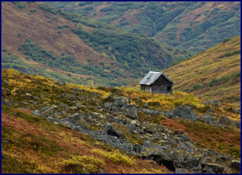
The trail began by winding down through the willow bushes,
passing an old abandoned mining cabin, and crossing Fairangel Creek.
We picked blueberries along the way, now fully ripe and much
better than the ones we had sampled ten days earlier.
We followed the narrow path as it passed several beaver ponds
and small lakes, and then climbed up through a hanging valley along
the creek.
The landscape was fabulous all along the way - it was much
more beautiful than I can possibly describe.
The colors were vivid; the tundra was painted with greens,
reds, and golds, contrasting with the bluish gray of the granite,
and the mountains were topped with new white.
As we climbed higher, we could look down on the valley and
admire the mountains from ever changing perspectives.
It was like we had the world to ourselves - we didn’t meet
anyone the whole day except two marmots.
As we neared the top the way became very steep, and in places
it was quite slippery - we carefully picked our way over the
boulders on the trickier spots.
The ascent gave us a good workout, but we’d had a bit of
training so to speak during the last ten days.
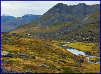
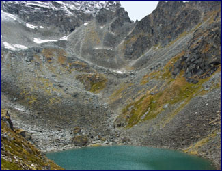
Presently we came out on a high plateau where a small lake
was nestled between the surrounding peaks; this was
Lower
Fairangel
Lake
. It was a tranquil
spot, with panoramic views of the valley below and the snow-tipped
mountains beyond. A
perfect lunch spot, but that would have to wait - we hadn’t
reached the upper lake yet.
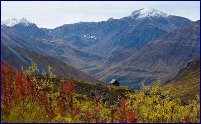
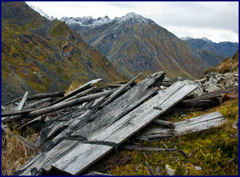
We continued up the steep rocky slope, well above the lake,
until we came out on a barren rock outcropping, where the remains of
an old miner’s cabin lay. We
were at the snowline, and the air felt very much colder.
We stood shivering beside the fallen timbers of the cabin,
looking down into the vale beyond it at the brilliant turquoise
waters of the glacier-fed
Upper
Fairangel
Lake
. We thought about the
miner who would have lived in this cabin in the early 1900s and
prospected for gold in these mountains, and the incredible hardship
and loneliness he must have endured.
We went back down to
Lower
Fairangel
Lake
, where we sat on a large rock and picnicked on trail mix and
brownies. We reflected
on what an amazing hike it had been, perhaps our best one yet.
On the way back down the trail we were able to enjoy the
beauty of this spectacular valley and the changing perspectives all
over again.
We went back to the Hatcher’s Pass B&B to shower and
finish packing, and then made the two hour drive back to
Anchorage
. Reaching the city
around 5:00, we still had about four hours until we had to be at the
airport, so we decided to head south of the city and explore a bit.
We drove along the shore of the
Turnagain Arm, a body of water branching off of the
Cook Inlet
. The Milepost told us
that it has a tidal fluctuation of as much as 33 feet, and the water
level can rise extremely fast. Many
people have drowned by going out on the mud flats at low tide, then
being unable to reach safety in time when the bore tide comes
rushing in.
The weather was overcast and the water appeared gray.
Tall mountains with snowy tops rose up steeply on the other
side of the inlet, partially obscured by heavy mists.
Highway 1 went right along the edge of the water, and the
railroad track paralleled it. The
Milepost said that you can sometimes see dolphins and beluga whales
in Turnagain Arm, but though we stopped several times to glass the
waters, all we saw were seagulls and bald eagles, flying along in
search of fish.
|
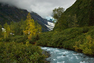
Portage Glacier
|
We saw a sign for Portage Glacier, so we turned down the
small side road to take a look.
The glacier was quite large, with many branches of blue-green
ice visible creeping down the mountainsides.
Tiny icebergs floated in the lake below it.
Even though Portage Glacier is close to
Anchorage
and is a big tourist attraction, being both late in the day and late
in the season, the area was pretty much deserted.
We had the road to ourselves.
We checked out the
Whittier
tunnel; it was completed just a few years ago to connect the town of
Whittier
to the Alaskan road system. We
contemplated driving through the tunnel, but there was a hefty toll
so we didn’t bother. It
was around seven o’clock and just starting to get dark; we would
have to think about heading to the airport before long.
We turned around and started back toward
Anchorage
, driving slowly and looking for a likely spot for happy hour while
reflecting on what a great trip it had been.
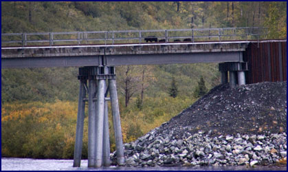
Jineen was driving as we approached a bridge over a small
river. To our right,
about 300 yards upstream, was a trestle where the railroad track
crossed the river and entered a tunnel into the side of the
mountain. Suddenly
Jineen let out a shriek and slammed on the brakes.
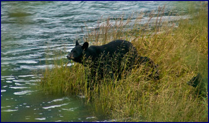
She had spotted, to our utter astonishment, a bear.
Well, actually, four bears.
A mother black bear and her three cubs were crossing the
railroad trestle over the river!
We couldn’t believe our eyes.
We watched from a distance as the family made their way along
the trestle. When they
got about a third of the way across, suddenly the mother turned
around and brought the three cubs back off the bridge.
They walked down the embankment and disappeared into the
bushes. About a minute
later we heard a train coming; it crossed the trestle and vanished
into the tunnel. The
mother bear must have felt the vibrations of the approaching train,
and that is why she reversed course and brought her babies back down
off of the tracks. Unbelievable!
After having pretty much given up on it, we had finally seen
our bear. In fact, a
whole family of bears! What
unbelievably good luck.
Hoping that we might get another
glimpse of the bear family, we parked the car, poured a glass of
wine, and settled down for happy hour.
We thought if we waited a while they might appear again, and
sure enough, after about 15 minutes they briefly emerged down by the
rivers edge, now a little closer to us.
They paused by the shore before disappearing again into the
dense willow thickets.
I got out of the car and walked
ahead to the bridge to see if I could catch a glimpse of the bears
from that viewpoint. To
my astonishment, I found that they had worked their way down the
river towards us; they were now beside the water less than 100 feet
from where I stood on the bridge.
I turned back to the car, wildly beckoning to Jineen while
trying to avoid making noise that would frighten the bears.
By the time Jineen joined me on the bridge, they had slipped
back into the underbrush again, out of sight.
We waited, and soon our patience paid off.
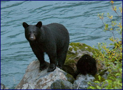
To our amazement and lasting delight, the mother bear once
again emerged from the undergrowth and stood by the river, but
closer now, right next to the bridge, no more than 50 feet from us.
Her cubs snuffled around among the boulders at her feet.
It was really the perfect bear sighting; normally it would be
very dangerous to be so close to a mother bear with her cubs, but
because of our position on the bridge we felt safe.
And we got our close-up bear photos!
The mother bear stood poised on the rocks,
sniffing the air and looking around - and then suddenly she saw us.
She stood motionless, silhouetted against the turquoise
waters of the glacial river. For
several timeless moments she made eye contact, staring right at us. Somehow
she seemed to understand that we were no threat to her family. It
was sheer magic. Presently
she and her cubs turned away and moved off through the thickets,
disappearing into the gathering darkness.
Jineen and I got back into the car and slowly headed north,
following the shore of the Turnagain Arm toward
Anchorage
, toward the airport, toward the plane to take us home.
|
“How
long the road is.
But for all the time the journey has already taken,
How you have needed every second of it in order to learn
What the road passes by.”
~ Dag Hammarskjöld ~
|
|