|
Wednesday August 8
Another great B&B breakfast, and Jineen got the recipe
for the scones. We
stopped off at the grocery store in Clifden to replenish our Happy
Hour supplies but sadly it was too early to buy wine.
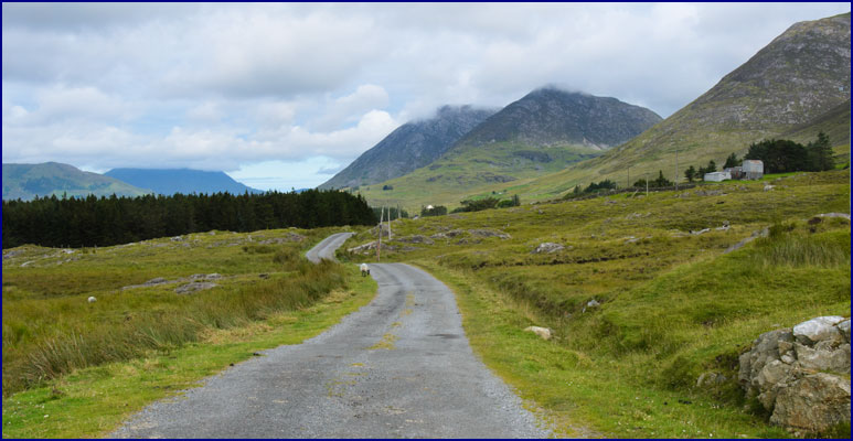
We headed back to the Maumturk Mountains, to do the hike
that we had abandoned because of rain earlier in the week.
We took the main road east past
the town of Recess, and then turned north on the small lane
through the Inagh Valley. We
parked by the road and headed up the rocky hillside on the Western
Way, a hiking trail that traverses Connemara for over a
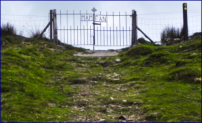
hundred miles. Before
long, as we ascended a steep slope, we found a wire fence across
our path, and an iron gate wrought with the word Mamean,
topped with a small cross. As
we approached it we could see nothing but sky beyond; it seemed
like the gate to Heaven.
Beyond the gate we walked steeply uphill as the path
climbed up the side of the mountain, passing only the occasional
sheep. It was a
beautiful day, the sky filled with fluffy clouds among patches of
blue. As we climbed
higher we had a grand vista; we looked back over the green
farmland of the Inagh Valley, with mountains in the distance and a
glimpse of water beyond.
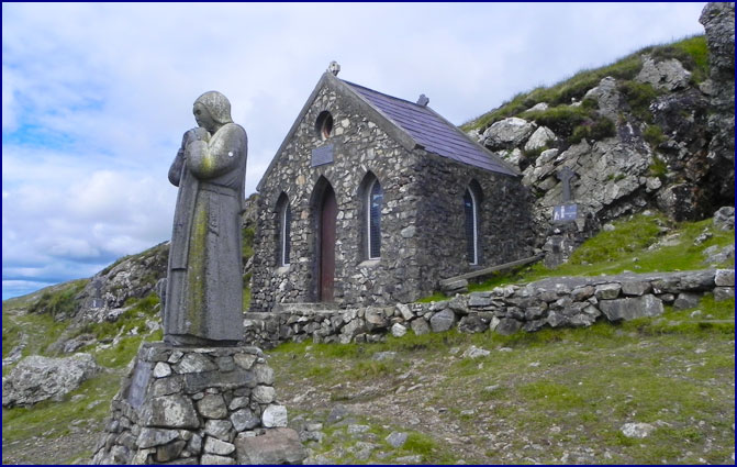
After about an hour we came to a tiny stone chapel near the
top of the Maumeen Pass. St.
Patrick himself is said to have blessed Connemara from this
beautiful spot. St.
Patrick�s Chapel is nestled on the shoulder of the mountain
known as Binn Chaonaigh.
Beside the chapel is
an outdoor altar, sheltered by a cave-like alcove of stone.
A statue of St. Patrick stands in front, looking down over
the Inagh Valley, a sheep at his heels.
A path meanders in a loop around the chapel, with Celtic
crosses amid the rocks and heather, marking the fourteen Stations
of the Cross.
|
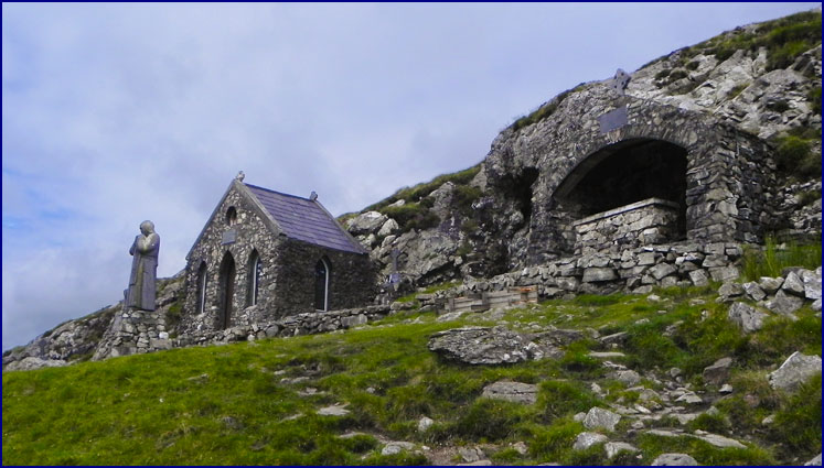
St. Patrick's Chapel, Maumeen Pass
|
When we first got to the chapel, a small group of hikers
was there with a guide. Everyone
gathered round as he told them about the history of this amazing
place, and we were able to listen and learn:
M�m
�an (Maumeen in English) means �Pass of the
Birds.� A place of
worship on this site was founded by St. Patrick in the year 432.
We learned that St. Patrick (or Ph�draig,
in
Irish) was born in Wales.
When he was a child he was kidnapped by pirates and brought
to Ireland to work as a slave.
He managed to escape after six years in captivity and
return to Wales, where he joined the church and became a bishop.
In 432 he returned to Ireland to bring Christianity
to the Emerald Isle. He
founded numerous churches around Ireland, including this one at
the pass of M�m
�an.
In the 1600s, as the guide told
it, the King of England decided he wanted the tithe that the
people paid to the Catholic Church to come to him instead, so he
abolished the Catholic religion, and sent Oliver Cromwell to
Ireland to enforce his new law.
What followed was a bloody massacre, and the Irish people
still consider Cromwell a pirate and a villain.
Faced with the penalty of death if they were caught
practicing Catholicism, the local people met in secret at the
Maumeen chapel to worship. It
was located high on the pass between the Inagh and Maam valleys so
that people from both areas could attend.
From that high vantage point they could see enemies
approaching in time for the congregation to disperse and hide.
To
this day, services are held at the chapel three times a year, and
they are sometimes attended by upwards of a thousand people.
Pretty impressive, considering what a trek it is from the
valley up to M�m �an pass.
Soon the hiking group left and we had the place to
ourselves, except for a few sheep.
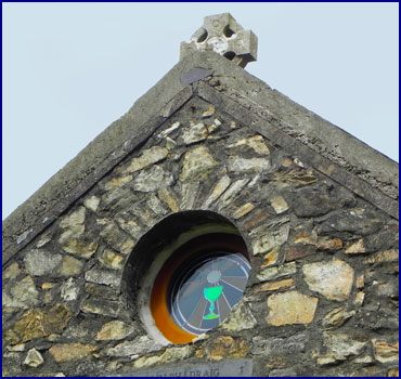
The chapel itself was locked so we could not enter.
It is constructed of stone, and has a heavy wooden door and
stained glass windows. There
is a small circular window above the door, recessed in the thick
stone walls, its stained glass depicting a bright chalice against
the rays of a rising sun. Beneath
it is a stone plaque, inscribed with the name of the chapel, Cill�n
Ph�draig. Patrick�s
chapel. Beside
it, in a stone recess, is the altar, made from green Connemara
marble. People had
left mementoes in the crevices of the stone wall behind the altar;
photos, candles, figurines, coins, and jewelry in memory of loved
ones. A poster
memorializing a local man who had died as a firefighter in 9-11
hung on the wall. We
left some coins of our own, solemnly, silently projecting our own
good wishes.
We
stood behind the marble altar, looking out from the cave at the
pass before us and the panoramic view of the valley below.
It was an incredible feeling to stand there in this place
of worship, founded by Saint Patrick in the year 432.
I am not a churchgoer, but it seemed to me that one could
feel close to God here.
I have to admit that until this experience I had not fully
realized that Saint Patrick was a real person; I guess I had
vaguely assumed him to be a myth.
Standing in this high place, it was gratifying to learn
that
Ph�draig was real, and to know that we were
standing where he had once stood, looking out over the same valley
he had gazed upon, and that it probably hadn't changed all that
much.
A
bit further down the hillside we came to an ancient
horseshoe-shaped stone wall enclosing a small spring.
It is marked with a stone engraved Tobar
Ph�draig
, meaning St. Patrick's Well.
Supposedly the water from this well had restorative powers;
we dipped our hands in it, but it looked a bit stagnant so we were
afraid to drink it.
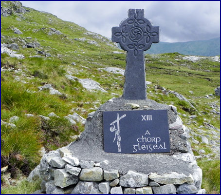
We
followed the path that wanders among the Celtic crosses
that depict the fourteen Stations of the Cross.
Each stands on a stone pedestal, with a slate engraved with
graphic sketches, the Roman numeral, and a title in Irish Gaelic.
Up the hill behind the chapel, we found what appeared to be
another well or spring, down inside a cave-like stone springhouse.
|
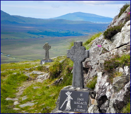
The Stations of the Cross
|
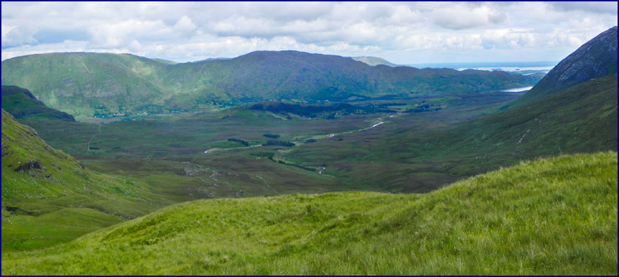
From the chapel, it was just a few hundred yards to the top
of M�m
�an pass. We
stood on a rock outcropping and looked down over the Maam Valley.
We could see the well-worn path of the Western Way winding
down the green valley before us - it looked inviting, but our
route headed upward - we were planning to climb the mountain above
the chapel, Binn Chaonaigh.
We
had gotten directions to the summit from our Lonely Planet Hiking
Ireland book. It also
gave us dire warnings: Any
walk in the Maumturk Mountains is a serious undertaking.
The terrain is more rugged than it looks from below, and
accurate route-finding is a challenge.
Unless you are confident of your navigation skills, it is
best to tackle the Maumturks only in good weather � clouds can
roll in quickly, obscuring visibility and making route-finding
particularly.
We weren�t worried; the weather was fine and visibility
was good. And anyway,
we could see the top of the mountain from here, so how hard could
finding our way be?
We left the Western Way and
climbed steeply up the mountainside, following the rather sketchy
directions from our Lonely Planet book:
Set a northeasterly course toward a grassy spur at the foot of low
bluffs. Cross a fence
and climb steeply northwest towards the crest of the spur.
Too bad we didn�t have a
compass.
Our
directions continued: Climb
northwest to a bumpy plateau strewn with rock slabs and masses of
shattered white quartzite. The
summit, Binn Chaonaigh, is set about 100 meters northwest of a
tiny lough. There are
occasional traces of a stony path underfoot, although it isn't
continuous enough to provide reliable guidance.
How hard could it be?
Apparently, harder than we thought.
It soon became clear that once we climbed that first grassy
spur, there was no path to follow.
We scrambled up the impossibly steep mountainside, picking
our way across rock outcroppings and skirting small pools and
tarns. Soon our legs
were burning, and we were quickly gasping for breath.
The terrain varied, with grassy slopes, wet bogs, and rocky
cliffs, but it was all relentlessly steep, and we were never quite
sure if we were going the right way.
We would struggle uphill for as long as we could, then stop
to rest and regain our breath before clambering upwards again.
We realized that what had appeared to be the top of the
mountain when we gazed up from the chapel was just a knoll, and
that Binn Chaonaigh was
much higher than we had thought.
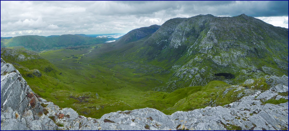
|
The Maam Valley |
The higher we climbed the more spectacular the views
became. From such
lofty vantage points we
could glimpse the coast beyond the Maam Valley, and spectacular
mountains rose in all directions. We
stopped on a steep high slope and sat on the rocks, resting a bit
and admiring the view. We
ate a bit of trail mix for energy.
We
picked our way up the top part of the mountainside, following
untrodden ways. We were looking for the path of least
resistance, or indeed, for any path at all.
We passed many pools, each time thinking that this
one must be the tiny lough near the summit that our woefully
inadequate directions referred to, but each time finding that the
mountain continued unrelentingly upwards.
We often found our way blocked by bogs or cliffs, and would
have to backtrack to find another route.
We tried to mentally keep track of our turnings for the
return trip, but it was impossible.
As we neared the summit, the grassy areas were replaced
with stone, and soon we were clambering over solid rock.
We were exhausted; if we had known how hard it would
be to climb this mountain we would never have started in the first
place - but having come this far, we were determined to go all the
way. We
made a final push for the top, struggling rubber-legged and
gasping for air to the huge rock cairn at the summit.
We stood atop Binn
Chaonaigh, 633 meters high, feeling an intense sense of
accomplishment.
|
Looking north from the
summit of Binn Chaonaigh
|
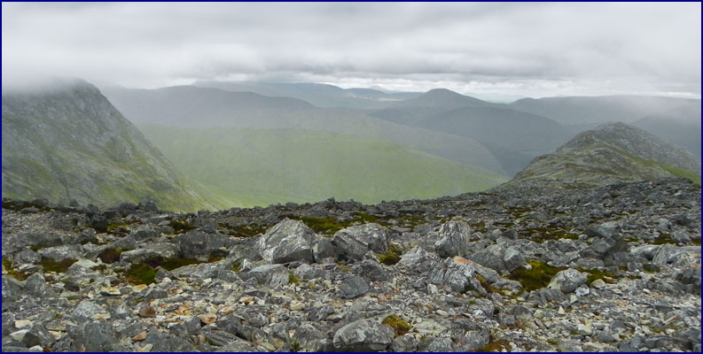
The top of the mountain was a world of barren rock, very different
from the verdant valleys we had left below us.
We looked around us at the breathtaking view in all
directions. The whole
of the Inagh Valley was stretched out below us to the west, and to
the southeast we could see over the Maam Valley all the way to the
coast. To the north
was a sheer-sided mountain, partially obscured by an impressive
cloudbank that was moving toward us.
Uh-oh, wait a minute.
Remembering
the guide book�s warnings, we realized that we could be in
trouble. The weather
was closing in on us, the gathering clouds hiding the sun.
A dense wall of white mist rolled toward us, gradually
obscuring the mountaintop. If
that thick cloud overtook us we would have no visibility at all.
We would have liked to stay at the top for a while, but we
dared not linger. We
each pocketed a small stone for a souvenir, and then started back
down the mountain immediately.
Fortunately once we got a bit lower we were below the
clouds, and the visibility improved.
We made our way down the treacherous slope on weary legs,
avoiding precipices and impassable bogs, doing our best to retrace
our steps. Eventually
we got back down to St. Patrick�s Chapel, and then finally down
to our car, seven hours after we had left it.
|
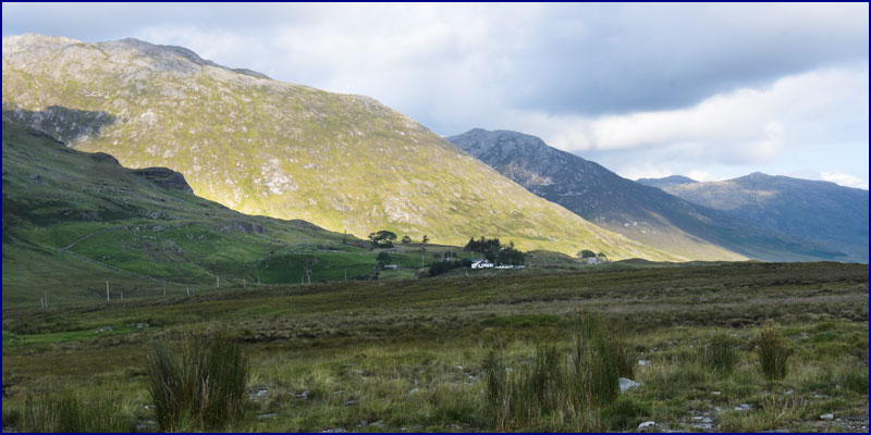
The Inagh Valley
|
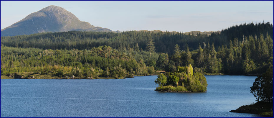
We drove back down through the Inagh
Valley looking for our donkey friend, but he was nowhere to be
seen. Heading back
toward Clifden, we stopped off at Ballynahinch Lough, a huge lake
surrounded by evergreen forest.
This was one of the few areas we had seen in Connemara with
many trees. Out in the
middle of the lough sits a tiny island with the ruin of a small
castle on it, half covered in ivy.
This fortress was built in the 1500s, and was inhabited
by the famous pirate queen, Grace O�Malley.
It later served as a prison for those who had
ill-treated animals. It
figures that Ireland would have a special jail for those who are
mean to animals; how great is that?
We returned to Cleggan and checked into the Hazelbrook
B&B for the night. We
enjoyed dinner and live music at the seafood restaurant near the
Inishbofin ferry.
|