|
Day 2 - July 29
It was still dark when we woke
up - surprising considering the long days this far north brought
early dawns; we hadn't anticipated waking so early. But
then glancing at the clock I saw it was 7:35, and drawing back the
curtain revealed blazing sunlight; it wasn't dark after all, but
the heavy curtains had completely shut out the light.
We headed north on the Icefields
Parkway. There were
few cars on the road so early, and we were enjoying the scenery,
anticipating what the day would hold.
And it wasn't long before we had our first adventure:
a wolf, crossing the highway in front of us!
A dark-coated canine shape appeared out of the trees on the
right, then padded across the road about 100 yards ahead of us,
pausing to give us a good look before disappearing into the pines.
It is not common to see wolves in the park, and we
considered ourselves very lucky indeed.
A short while later, while we were
still congratulating ourselves on our wolf sighting, we had
another adventure cross our path; this time a young grizzly bear
ambled across the highway. We
couldn't believe our luck! Jineen
quickly braked the car while I grabbed for my camera, but much to
our dismay the car behind us accelerated past, scaring the bear
into the underbrush before I could get a shot of it.
But still, a wolf and a grizzly bear, in the space of half
an hour!
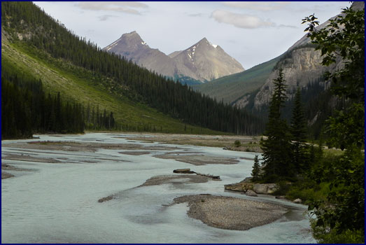
The parkway went alongside a
river, which widened out to many channels through a broad rocky
flat. The road made a
huge loop, like the world's biggest switchback, and headed steeply
uphill to a pass known as 'The Big Bend.'
We stopped at the top to gaze at the panoramic views; the
road we had come on lay like a winding ribbon down the valley far
below us. Looking
across, we were eye level with glaciers and snowfields.
A white frothy stream cascaded thousands of feet down the
mountainside.
|
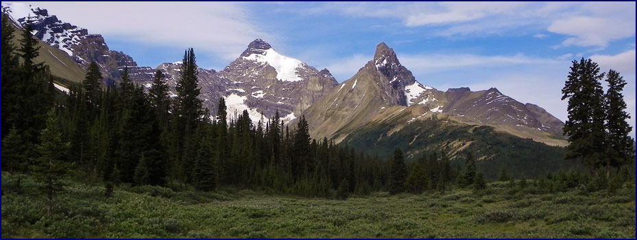
Near
the Big Bend
|
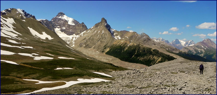
Our hiking destination was Parker's Ridge.
It was rated as a Premiere
hike in Don't Waste Your Time in the Canadian Rockies, and several other
books had advised us that, "If you do just one hike on the
Icefields Parkway, make it Parker's Ridge."
Even with this grand buildup, it exceeded all expectations.
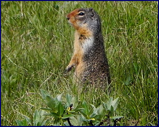
Setting off from the parking lot,
we were greeted by a Columbian ground squirrel, who kept popping
up out of his burrow to check on what we were up to.
We paused to reassure him, and then headed uphill.
The trail went up a series of switchbacks, in and out of
the forest, with beautiful views of the mountains right away.
At first the upward grade seemed quite manageable, but the
higher we went the more trouble we had catching our breath; soon
we were huffing and puffing. The
climb was steep, but we were more out of breath than expected.
Then we considered the fact that we were hiking at an
elevation of around 8000 feet; the altitude was a killer.
Oh yeah, I would like some oxygen in my air please . . .
|
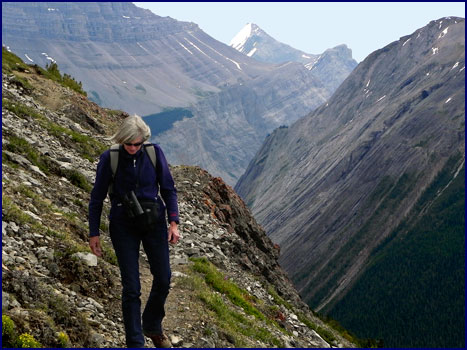
Starting
up Parkers Ridge
|
As we climbed higher the scenery unfolded before us,
becoming more spectacular with each meter of altitude gained.
We labored up the switchbacks, stopping to admire the views
(and catch our breath) at each turn.
After about an hour of climbing we reached the ridge,
following the trail across the saddle.
We took a little path off to the left which crossed the
tundra and came out on a ledge overlooking the canyon below.
We looked around in awe.
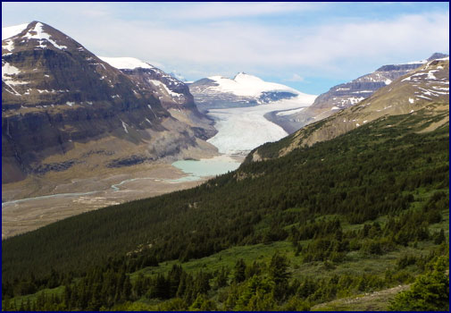
We had an incredible view of the
Saskatchewan Glacier in all its glory, a giant river of ice
snaking down between snow-clad peaks.
A chalky greenish-gray watercourse ran down from the
glacier through a field of rock.
Further downstream, bright green-blue inkpot pools from
underground springs accentuated the glacier-carved canyon.
We could just barely make out a trail along the bottom far
below, where one could hike up the valley to approach the glacier.
Across the canyon stood a sheer rocky mountainside of
vertical cliffs, where a stream fed by snowmelt fell thousands of
feet down a series of high waterfalls. Tall
mountain peaks rose around us, imposing margins to this vast
landscape.
|
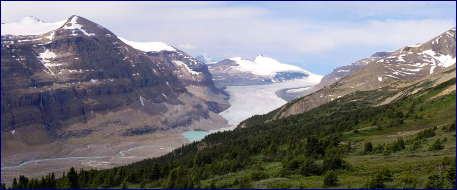
The
Saskatchewan Glacier from Parkers Ridge
|
Winding among the rock outcroppings, we followed the tiny
path along the cliff top until it petered out in a boulder field.
We had seen several other groups of hikers earlier, but we
had long since left them behind, and we reveled in the seclusion.
We found fossils in the rocks; thousands of tiny seashells
from a time when this land was the sea, preserved for all eternity
in the stones beneath our feet.
We sat for a long time on the side
of the ridge, looking down over the canyon, isolated from the rest
of the world, feeling incredibly peaceful and serene.
The wind was in our faces, and passing clouds accented the
blue sky; sun and shadows. A
golden eagle soared high above, dark against the sky, and then
spiraled down the valley below us.
|
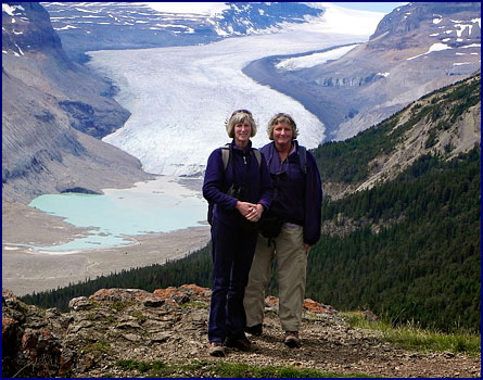
On Parkers
Ridge
|
Presently we made our way back along the cliff edge to the
saddle, and then hiked up the other side to a high knoll.
The view from there was expansive, 360 degrees around us.
The wind was really strong, almost blowing us off our feet.
We both felt an incredible sense of exhilaration.
I held my arms out and felt like I could fly.
The powerful
notes of the John Denver song 'Aerie' were running through my
head, and I was singing along in my mind with the wind:
I
am the eagle, I live in high country
In rocky cathedrals that reach to the sky
I am the hawk, and there's blood on my feathers
But time is still turning, they soon will be dry
And all those who see me and all who believe in me
Share in the freedom I feel when I fly . . .
|
Parkers Ridge
|
We lingered at the top of the knoll, looking at the views
all around us. Rock
cairns had been built up into little semi-circular shelters, where
one could sit and take
refuge from the wind. Fortunately
it was warm and sunny, but we could well imagine how bitter it
would be on that exposed ridge on a stormy day.
All too soon it was time to head
back down the trail. It
was like making a gradual return to civilization as we descended;
we started passing other hikers again, and as we got lower we
could hear the sounds from the highway. Walking
down the steep switchbacks proved to be much easier than going up.
The little ground squirrel welcomed us back to the car
park, five hours after we had left.
We
continued up the Parkway along the Columbia Icefield, with
glaciers coming into view at every turn.
Reading our guide book, we learned that the 200 square mile
icefield spans the border between Banff and Jasper parks, sitting
astride the Continental Divide. Receiving
up to seven meters (23 feet) of snowfall per year, it feeds eight
major glaciers, and is over a thousand feet deep.
From the Parkway we had a terrific view of the Athabasca
Glacier, curving down the valley from the icefield high above.
|
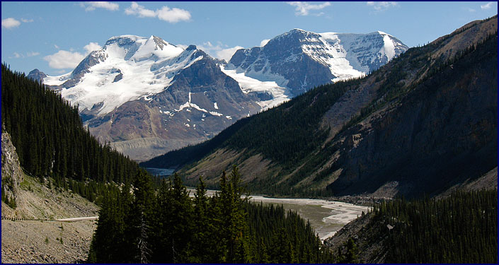
Athabasca
Glacier
|
We stopped for cokes at the Columbia Icefield Center, a
huge building just across the highway from the Athabasca Glacier.
We figured it could also be called the Columbia Icefield
Tourist Trap. We
accidentally turned into the bus parking lot, and got in the queue
where a dozen buses were disgorging their passengers to join the
crowd at the center. There,
in addition to having a
fabulous view of the Athabasca Glacier, one could visit the
icefield museum, the interpretive glacier display, the glacier art
gallery, the cafeteria, the restaurant, and several glacier gift
shops. You could even
go on a snow-coach tour of the glacier itself. It
was just the sort of place that we try to avoid like the plague.
But desperate for some caffeine, we waited in line at the
cafeteria to pay eight dollars for two cokes.
Upstairs there was a hotel; we pitied the poor schmucks who
stayed there.
The icefield and glacier were very
impressive; it was the overt commercialism of the Center we didn't
like. But a bit
further up the parkway, we found a lookout point with awesome
views of the icefield and glacier, and the gorge below it,
unspoiled by buildings, buses and crowds.
We continued north on this
incredibly scenic highway, hitting the highlights.
We came to Tangle Falls; it was a very pretty waterfall
right by the road, if you could get past the dozens of Japanese
posing to have their picture taken in front of it.
At Mount Kitchener, another huge glacier overlooked a broad
many-channeled river. We
drove down a long stretch where the road paralleled a ridge of
layered mountains peaks, set in a repeating pattern, all shaped
the same. We stopped
at a scenic overlook where a sign indicated mountain goats might
be seen; we searched the rocky cliffside with our binoculars
but couldn't spot any.
Our next stop was Athabasca Falls,
considered one of the most impressive waterfalls in the Rockies.
The Athabasca River thunders through a narrow gorge; the
force and power of the churning water is almost scary.
It is a really beautiful waterfall, and a very popular one.
To me, this incredible piece of nature has been somewhat
ruined by the park service building viewing platforms, walkways,
and bridges right up against the falls, spoiling the chance to
look at them unobstructed. I
realize that the parks only exist because so many people visit
them, yet I can't help wishing that the land could be left as it
had been created.
We turned down route 93A, a small
gravel byway that roughly paralleled the main highway.
We passed Leach Lake; its deep green color was accented by
the red Indian Paintbrush and the fluffy white puffball flowers
that lined the road. We
drove beside a swift glacier stream for a while, before finally
coming to a small deserted carpark. We
walked along a wooded path for about a kilometer to Maob Lake.
It was surrounded by forest, and many small side trails led
to fishing spots along the shore.
Looking across the lake to the mountainside beyond, we
could see that the trees were dead and burned; an informational
sign told us that lightning had started a forest fire in 2000, and
in accordance with the current policy of letting nature take its
course, the forest rangers had controlled the fire, but had let it
burn.
By the time we left Maob Lake, it
was getting on to evening, which is a good time for spotting
wildlife. We passed a
mule deer by the side of the road.
Back on the main highway we approached the town of Jasper,
and we were excited to see a young spike elk, grazing right beside
the road. We carefully
eased the car on to the shoulder, hoping to get his picture
without frightening him. As
it turned out, you couldn't frighten him if you tried; he was as
tame as a cow. Cars
pulled right up next to him, and people stood within feet of him
to take his photo; he was totally unconcerned with the passing
traffic. Sort of like
the deer in Loudoun County!
|
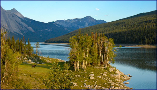
Medicine
Lake
|
We turned down the Maligne Lake road, driving slowly and
watching for animals. The
road skirted the shore of Medicine Lake; it was a deep robin's egg
blue, and absolutely stunning.
We spotted three bull elk, lying in the grass down near the
water. We followed the
road on to Maligne Lake; it is normally a busy spot, but this late
in the evening there was nobody there.
After walking around a bit, we headed back toward the main
highway. As we
returned past Medicine Lake we saw one of the elk was still there,
now standing, grazing by the side of the lake, illuminated in the
slanting rays of the evening sun.
It was dusk by the time we
were back on the main road, heading east from Jasper town.
A small herd of mother elk with their calves grazed in a
meadow not far from the road; they moved away nervously when we
stopped the car.
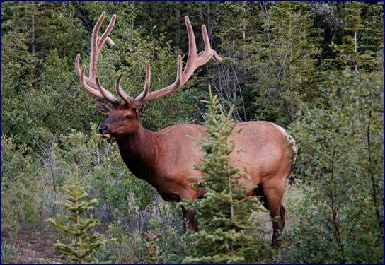
A mile further up the road, we
came upon a huge bull elk, grazing contentedly by the side of the
road. He had an
enormous rack of antlers, covered in velvet.
He posed for us while we photographed him in the dusky
light, turning to display his best side.
Nearby we saw two more of his friends, the largest boasting
a rack of 17 points.
It was almost ten o'clock by the time we reached the town
of Hinton, where we were staying the night at the Twin Pine Motel.
It had been a great day, very busy, and we hadn't wasted a
moment of it. After a
quick dinner at the A&W diner, the only place in town still
open, we fell into our beds exhausted near midnight.
|