Day 9: November 18
We had breakfast in our B&B, enjoying great homemade bread and a beautiful view of the mountains over Lake Wanaka. The house we were staying in was very interesting, filled with artwork and antiques from all over the world. There were also accommodations for backpackers in the basement; we had noticed a number of places that offered very basic but economical lodging for the many people hiking their way around NZ on a shoestring budget. The man who ran the B&B had only been doing this for a relatively short time; he was a retired sheep farmer who used to have over 6000 sheep! There was a fabulous painting in his living room; he was on a horse amid hundreds of tightly packed sheep, his dogs helping to herd them, with an injured lamb carried over the front of his saddle.
The white stone from the beach and the greenstone from the river were once again in my pocket; I hadn’t had the heart to throw them out yet, so they would accompany me for the day. We headed out early to go tramping. But oops! When we got about 5 kilometers from town we realized we had forgotten to get fuel; and since the gauge showed we were just below half a tank, we turned around and went back to the petrol station. Once sufficiently supplied we retraced our tracks and headed out again.
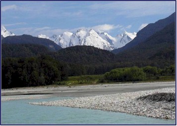
We followed the shoreline of Lake Wanaka for a while, and stopped at a lovely spot called Glendhu Bay for a view of Mt. Aspiring in the distance, with its 3027 meter peak visible above the shoulders of the closer mountains; it was very distinctive with its sheer face and impressive snowfields. A great spot for a photo!
We turned off onto a little side road; we followed it through farmlands and sheep pastures, and the road became smaller and smaller. We passed a site that was marked on the map with a golden ring; it was a “Lord of the Rings” film site labeled as ‘The Rugged Country south of Rivendell.’ We drove down the small lane; a sign indicated that it was a private road, but it still seemed to be open for traffic as it wound through farmyards and across streams before eventually coming to an end by the river.
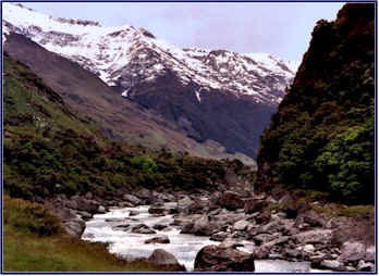
Back on the road to our destination, we followed the course of the Matukituki River towards Raspberry Creek Hut, where our hike was to start. As we traveled further up the valley the mountain scenery became more and more spectacular as the road narrowed. We passed huge sheep farms, and also paddocks of red deer with very high fences. A small lake was the home of a pair of black swans. A farmer tilling his field with a tractor was followed by a flock of seagulls, which were eagerly swooping down on the worms and insects unearthed by the machinery. As we came to the end of the road it turned to a narrow track, crossing a number of creeks and streams by way of open fords; the last one was quite deep, and we felt that it justified our decision to rent a four-wheel-drive vehicle! The valley became narrower and the mountains on either side were very steep. We saw a lovely waterfall on the left, where a small creek cascaded down a sheer cliff.
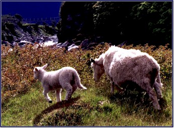
When we finally came to the end of the roadway there were several sheep farmers working with their dogs, penning a large herd of sheep and ear-tagging the lambs. We watched in fascination as they signaled the dogs to separate groups of sheep and herd them into a temporary enclosure. One lamb jumped the fence and made a bid for freedom; in a heartbeat one of the dogs caught it and pinned it down until the farmer could get there; he threw it over his shoulders and returned it to the herd.
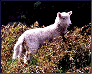
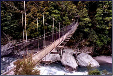
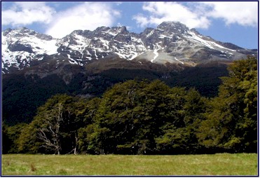
We hiked the Rob Roy Track; it was a fabulous 5 hour tramp that took us up to a glacier. The track started by winding through grassy sheep pastures, where we saw lambs cavorting and playing tag. We then crossed over the Matukituki River on a narrow swing bridge suspended by cables high above the rushing water; it swayed and vibrated alarmingly as we walked carefully over it. The path started to climb up through the forest, following a small river that came leaping swiftly and forcefully down over the boulders in a series of rapids and cascades. The water was a chalky green color, and many of the rocks and wall faces in the streambed were vivid green as well from the minerals in the stream.
The trail climbed steadily up the side of the mountain, and in places it was obliterated by rock slides. Occasionally the way was quite steep, but on the whole it was a fairly easy hike; especially compared to the one we had done at Arthur’s Pass! We encountered other trampers at intervals along the trail; it was quite interesting to talk to them about their experiences in NZ. One of the questions that would always come up was “how long are you here for?” and it seemed that most of the trampers we met were visiting for at least several months; one couple from Germany had taken over a year off from work to travel the world!
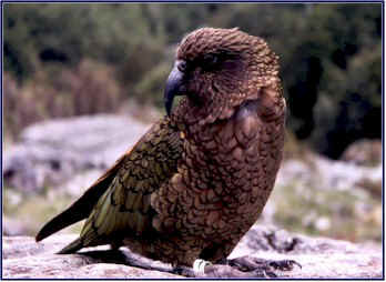
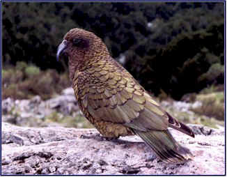
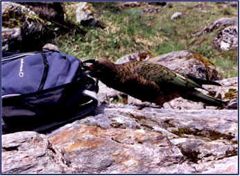
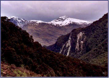
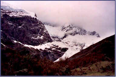
Eventually we came out of the forest and reached our destination; a large open area high up on the side of the mountain, with a great view of the Rob Roy Glacier. We sat on some rock outcroppings and ate our lunch; fresh bread, cookies, and oranges that we had brought in the backpack. But soon we had friends! We were joined by two keas who hoped to share our meal; they came and sat on the rocks beside us, trying to coerce us into feeding them. As there was a large sign nearby reminding us; “Do not feed the keas”, we refrained (mostly), though they did clean up the crumbs. Whenever another hiker would arrive to the area they would fly away to investigate, in case the newcomer hadn’t read the sign; but they would soon return to us, as we were the only ones eating. After a while they became bolder, and soon they were trying to get into our backpack. One of them actually unzipped it with his beak and tried to crawl inside to steal food; he and Jineen ended up having a tug-o-war for possession of it!
From our lofty vantage point we had a good view of the snowfields and flowing ice of the glacier. High up above us, there was a huge wall of ice along the edge of it; we estimated it to be 60 to 80 feet thick in places. We sat watching for quite a while, hoping to perhaps see a piece of the glacier break off, or perhaps an avalanche. Jineen in particular was convinced that if we stayed long enough the glacier would give us a show; but we waited to no avail.
It was a beautiful day, mostly sunny with just a few passing clouds. Once again we were struck by how lucky we had been with the weather, and also by how much we had over-packed in the way of coats and warm clothing! We had expected much colder temperatures. It was cool and quite breezy up high on the mountainside, but we were comfortable with light jackets.
Just as we were packing up and preparing to start back down, it happened: we heard a loud echoing boom, like a cross between ice cracking on a frozen lake and thunder. As we watched, a big chunk of the glacier broke off, and seemingly in slow motion it crashed down the mountainside with a small avalanche of ice and snow trailing behind it. It was awesome! We couldn’t believe our luck. What an amazing experience the whole afternoon had turned out to be. You wouldn’t get this on the bus tour!
We hiked back down the mountain and returned to the car; it was time for our now-traditional Happy Hour. We had bread and cheese, and finished off the Cloudy Bay. We then drove back past Wanaka, and headed towards Arrowtown.
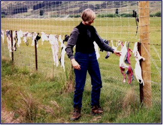
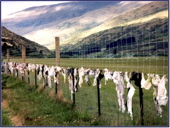
Traveling south through the Cardrona Valley, we came upon ‘bra fence.’ For some inexplicable reason, women in New Zealand have put their brassieres on this section of fence along the road; there is now a stretch for several hundred yards that is covered with thousands of bras. We didn’t want to pass without making a contribution, so Jineen left her bra in the company of the others.
We came to the summit of Crown Range Road; we were at the top of a high pass looking down over Arrowtown. We made the hair-raising drive down the mountain on this incredible piece of highway; it consisted of a series of absurdly tight switchbacks and hairpin turns going down an extremely steep grade. The road was very narrow, and the turns were so tight you couldn’t go more than about 5 mph around them; and this was a main route! There were drop-offs of hundreds of feet; needless to say, no guard rails. It was the most treacherous bit of paved road we had seen so far on this trip!
When we finally made it down the mountain, we drove about three times around Arrowtown before locating the New Orleans Hotel where we were booked for the night. It was being renovated and our room was only partially finished; it smelled of fresh paint, and the bathroom mirror was sitting on the floor. I opened the door to what I thought was a closet; I was shocked to find myself staring at a man in the next room. He was even more shocked than I was, as he wasn’t wearing any clothes!
We had dinner at a nearby café (the Beef Wellington was excellent!), and over wine, I started working on Jineen about the bungy jumping idea.
Day 10: November 19
We got up early and drove down by the river below town, where we walked along the shore. This was another of those “Lord of the Rings” sites marked on the map with a gold ring; it was where the ‘Ford of Bruin’ was filmed, when the flood washed away the Black Riders. It was a beautiful river, lined with yellow broom bushes; very peaceful in the early morning light.
We stopped in a small shop for some supplies, and breakfasted on Anzac biscuits (the name is an acronym for ‘Australian and New Zealand Army Corps’). Despite their origins as army rations, these crunchy little cakes made from oats and honey are quite tasty! Thus fortified, we headed for Glenorchy.
We passed through Queenstown; a small city that sits in a very picturesque setting on the shores of Lake Wakatipu. It is a popular tourist destination, but nonetheless we found it to have a very nice atmosphere. The Queenstown area is famous for its spectacular beauty and its abundance of interesting and exhilarating activities.
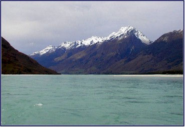
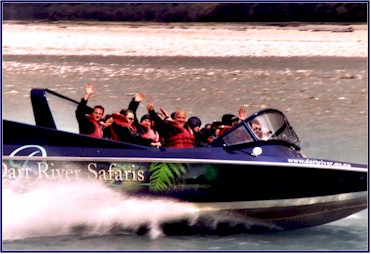
Lake Wakatipu is a huge Z-shaped lake of a beautiful blue-green color, surrounded by impressive mountains. We followed the shoreline and presently we came to the town of Glenorchy, a tiny town right on the top end of the lake. We went down to the pier to begin our next adventure; jet boating!
Jet boats are flat-bottomed boats that are powered by an engine which forces water out from the bottom of the hull, thereby allowing it to go in extremely shallow rivers. They are quite fast and very maneuverable, making for an exciting ride. Anthony was our guide; he was friendly and knowledgeable, and an excellent driver. There were 8 other people on the jet boat; Jineen and I sat in the very back. And one thing soon became evident; we were having more fun than anyone else!
We started out by going up through the head of the lake, and Anthony gave us a taste of the boat’s speed. When he would accelerate, the front of the boat would lift up off the water and spray would fly out behind us. Soon we were traveling up the Dart River; it had a very broad riverbed with interwoven streams. There were many channels, and the challenge was to pick the right ones to follow. Anthony navigated upstream with ease, speeding through the curves and often changing direction very quickly; water sprayed up on the tight turns as he wove in and out between the rock walls. The wind was blowing very strongly down the valley, and combined with our speed of up to 80 kilometers per hour it was an unbelievable force; at times huge clouds of dust blew up from the rocky riverbed. The roar of the wind in our ears made conversation impossible.
As we continued upstream, the river got narrower and the turns tighter; and soon we were missing huge boulders by mere inches. Anthony put the jet boat through its paces, racing ahead then cutting it hard to put it into a sudden spin. The other people in the boat were very quiet and somber; they showed few signs of enthusiasm, or indeed, of personality. Whenever we would spin or make g-force turns they would look apprehensive, and they were appalled if they got a few drops of water on them. In the meantime Jineen and I were laughing hysterically, to the evident approval of Anthony, especially when spray from the spins would give us a good splashing. We were definitely having the most fun!
The Dart River was surrounded by majestic snow capped peaks, and the scenery was remarkable. Anthony was very informative; he often stopped the boat to give us the local lore. We paused at a spot where a tributary joined the river; it formed a pool that was such an incredible shade of deep turquoise that it was hard to believe. We passed a place where the flat riverbed widened out to a grassy field, with an impressive backdrop of snow-clad mountains; we learned that this was another “Lord of the Rings” filming spot, the landscape surrounding Isengard. We also came to a place called Paradise, where the battle on Amon Hen was filmed. We were finding it more fun than we had expected to check out these LOTR film sites!
|
Isengard
|
Midway through the ride, we stopped and took a walk through a beautiful beech forest. Everything was covered in moss, and it looked like a fairyland. We expected a hobbit to step out from behind a tree at any moment! The short hike was not at all demanding, but some of the people in our group found it difficult; one girl with thick-soled shoes was particularly helpless. We came upon an area enclosed by a tall wire fence; inside it the underbrush was very thick and dense, quite different from the surrounding woods. Anthony explained that the fenced enclosure was designed to keep the deer from eating the vegetation; and thereby to show the natural environment of the beech forest. This project also gives the birds that live in the forest an area of unspoiled habitat. It clearly demonstrated the impact that the deer, an introduced species, had made on the ecosystem! Upon completing the beech forest walk, we returned to the jet boat and continued on the river.
Altogether it was a 3 hour trip, and we covered about 70 kilometers. We had an excellent view of Mt. Pluto, one of a group of mountains known as the Seven Sisters. We passed a place where a stream plummeted down to the river from a great height, forming a beautiful waterfall; Anthony told us that it was called Unknown Falls, so named because the area is so remote that until the jet boats became popular hardly anyone knew it was there. Above the falls is Unknown Lake, not visible from the river and seldom seen.
On the way back Anthony treated us to even higher speeds, as the wind was behind us now, and he did some great spins. The others in the boat sat stoically, but Jineen and I were giggling like mad. The rush of the wind, the sudden turns, the speed; these things combined to create a sense of exhilaration. The jet boat experience was not at all scary; but it was exciting, and it got us pumped up a bit. I had a sudden realization: I really DID want to bungy jump!
We had lunch in Glenorchy, and then visited Dart River Riding, another trail-riding outfit. The horses were thoroughbreds, and they looked quite nice; we kind of wished we had chosen this stables for our trail riding. We watched a group of local kids set out for a trek on their ponies.
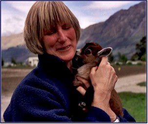
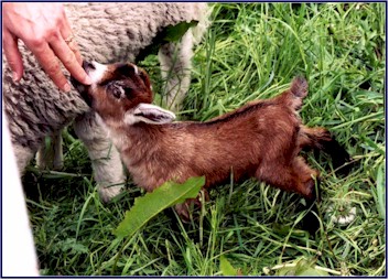
But the best thing about the place was the baby goat! In a small pen near the entrance, with a lamb for company, there was a baby goat; and it was just about the cutest thing we had ever seen. It was tiny, surely not more than a few days old, and just precious. I am sure it was bottle-fed, and it was trying to nurse on Jineen’s fingers. We tried to figure out a way to sneak it home in our suitcase!
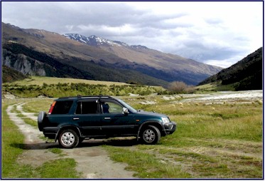
We then headed north and out of town for some back road adventures. We drove up the Dart River Valley to Paradise, which we had passed in the jet boat earlier. We were on a small unsealed road that crossed a number of streams by open ford; the last of these was quite long and deep, and the four-wheel drive came in really handy. Several cars were stopped there, the drivers afraid to test the waters, but our intrepid Honda went through with no problem.
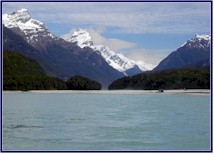
Paradise was a beautiful area, with open fields (or paddocks, as they call them in NZ) on gentle hills rolling right down to the Dart River, and forests that seemed ancient; all surrounded by a backdrop of snowcapped mountains. It did truly feel like Paradise and we thought the name appropriate; though Anthony the jet boat driver had told us that the area was named for the Paradise Bird, a type of colorful duck that lives there.
We drove down to the edge of the water to a place called Chinaman’s Bluff and walked along the riverbed. We again found greenstone; we had learned from Anthony that its technical name is scheelite. We made beech-bark canoes and tried to sail them down the river, but our boat-building skills were rather suspect; they generally sunk like stones. We walked along the rocky shoal to where the shoreline jutted out into the river and we stood on the bank, the wind was very strong and gusty. Jineen found a four-leaf clover. We watched several jet boats come by; they would speed close to where we stood by the shore and swerve sharply to try to spray us with water!
We located several more LOTR filming sites. Finding these locations was not something we had planned on when we started the trip, frankly it sounded a bit too geekish, but we found that we were quite enjoying it. We had obtained a ‘Lord of the Rings Guidebook’ which gave detailed directions on how to find and identify the movie locations; this was important, as the sites were generally not marked. We found the hunt sort of cool. (Whoops, I mean kuh-ool!)
We went through the beech forest where Boromir was slain by arrows, and we saw the spot where Frodo and his friends entered the woods at Lothlorien. We also stopped at ‘Dan’s Paddock,’ the place where Gandalph was filmed galloping up to Isengard. There was a rocky field alongside the road, and we could see some tracks where vehicles had driven across it; and further up the hillside we could see a blue sign. Naturally we decided to investigate; soon I was carefully picking my way up the gravelly scree, once again thankful for four-wheel drive, dodging large rocks, gullies and boulders, and trying to avoid puncturing a tire or oil pan. After carefully negotiating the treacherous field of stone we came to where we were close enough to read the sign, it said:
No Vehicles
Leave all Rocks
Whatever that means! The reason we had taken our vehicle off the road in the first place was to read the sign! And ‘Leave all Rocks’, what the heck is that about?
|
Paradise
|
Leaving Paradise, we passed the children and ponies that we had seen earlier set out from Dart River Riding; they had come at least 15 kilometers! We looked for the road that would take us up the Rees Valley, and after a couple of wrong turns we found it. It was an even less-traveled route, narrow and very steep in places, with stream crossings that were quite long and deep. The scenery was amazing. The brilliant colors of the lupine flowers that grew lining the road accented the majestic mountains surrounding us. We had asked about this route at the information center in the morning; they had advised us to go no further than the Invincible Gold Mines, which is where the road turns into a four-wheel drive track and becomes quite hazardous. Needless to say, we didn’t heed their advice, and we soon found ourselves going through a ford that actually required us to drive around a bend down in the stream; a sudden rainstorm could have easily raised the water level and stranded us. But the day was clear and we took our chances; we continued on to where the drivable track ended by the river.
We found ourselves in a secluded valley, and we had it all to ourselves. It was definitely very much off the beaten path. There was a huge grassy field behind us and the aqua river in front of us, with views of the mountains at each end of the valley. The wind was blowing down the river very strongly. It was a beautiful spot, and we loved the solitude. We parked near the river and had our Happy Hour; chutney on crackers and a Drylands Sauvignon Blanc; not brilliant but very nice, two stars.
|
Happy Hour!
|
We headed back to town and checked in at the Glenorchy Hotel. With our usual good timing, having enjoyed a lovely sunny day, just as we got to the door a sheet of rain moved across the valley and came pelting down. We hoped those kids on ponies had made it back ahead of the storm!
The proprietor at the hotel asked us where we planned to go the next day. We told him we were heading back to Queenstown, and inquired why he wanted this information. He said that the NZ authorities were encouraging hotels to record guest’s travel plans, because there had been problems with visitors disappearing and nobody knowing where to look for them!
We had dinner at the hotel; not a good decision. My shrimp was served still with the heads on, eyes, antenna and all; and Jineen’s seafood platter consisted of half raw fish served on a steaming hot brick, to which it scorched and adhered. Not very appetizing! On the whole we had found the food in New Zealand very good; but there are always exceptions.
We had some wine and I started to intensify the pressure on Jineen about the bungy jumping. She suggested that we go to Queenstown and watch some people jump, and then decide. This sounded good to me too; although I was trying to talk Jineen into jumping, I really didn’t know whether or not I’d be able to go through with it myself! But if we were going to do it at all, tomorrow was the day!
We went out after dinner and followed the Glenorchy River Walk. It was dark, but the moon peaking out through the clouds illuminated everything just enough so that we could find our way. It was extremely windy and spitting a little light rain on and off, but the air was warm and pleasant. We looked for possums and kiwis, but found neither. Later during the night it was very stormy and poured rain; but we were tucked away snug.
|