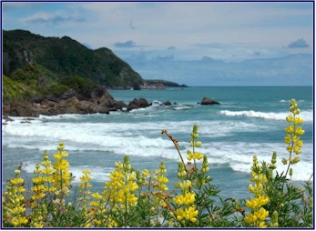
|
Day
3
We woke up early again, to brilliant sunshine.
The folks at our B&B had promised breakfast at 8:00 a.m.,
but since we were up by 6:30 they took the hint and prepared it
early. By eight we were
on the road.
We
backtracked a few miles and stopped in for a quick visit at the
Cloudy Bay Vineyards (having already visited the Bay itself at happy
hour). It was way too
early for them to be open for visitors, but at least we could say we
had been there.
Then
it was back on the road, heading west and inland, towards St.
Arnaud. We drove through
the heart of the Blenheim wine country, and it was very impressive.
The valley floor was fairly flat, with the mountains rising
up sudden and steep on either side.
We passed winery after winery; the level ground was filled
with thousands of rows of grapevines, with the majestic mountains of
the
Richmond
Range
forming a magnificent backdrop.
We had known that this was wine country, but we had no idea
that there would be such a vast expanse of vineyards.
Montana
, Brancott, Stoneleigh,
Cloudy
Bay
, Saint Clair, Fromm, Drylands, Allan Scott; these are just a few of
the wineries we passed.
The
road ran straight and true as we left the wine country, and
gradually the landscape became drier, even slightly barren in
places. The
Richmond
Range
still marched on our right, and the peaks became taller and more
rugged. We were
traveling up the
Wairau
Valley
, with the road paralleling the braided river.
We saw a sign with another one of the Highway Department�s
catch slogans. �Tired
Drivers make mistakes: Take a Break!�
As we continued west, the road began to steadily climb, and
it became quite twisty. As
we entered an area called �Six Mile Scenic Reserve,� we rounded
a bend and saw two wild pigs in the road. They
were as surprised as we were, and they quickly disappeared into the
underbrush.
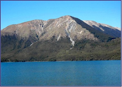
When
we reached St. Arnaud we visited the Department of Conservation
(DOC) information center to learn about the hiking in the area, and
then we headed for
Lake
Rotoiti
, in the Nelson�s
Lakes
National Park
. One of the most
fabulous things about
New Zealand
is its parks. Huge
portions of the country are in National Parks, Scenic Reserves and
Conservation Areas. Much
of this land is wilderness, with no roads through it, accessible
only by helicopter or on foot. The
DOC does an excellent job of maintaining the parks and hiking
tracks. This system is
truly one of their national treasures.
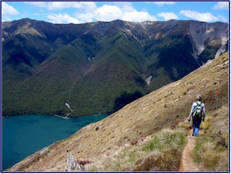
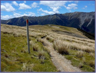
We decided to hike up
Mt.
Robert
. We drove up the
winding gravel road to the carpark, and set out on the Pinchgut
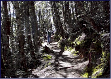
Track. The trail
immediately started climbing steadily, and we followed it up through
the beech forest. The
day was quite warm, and I was glad I had put on a sleeveless shirt;
in fact I was feeling a little silly for having put my long sleeve
shirt in my backpack �just in case.�
The
track wound upward through the shady forest.
The beech trees had an almost mystical quality, with moss
hanging off the branches and twigs.
Birds darted to and fro, their songs ringing out in the quiet
woods.
The path grew steeper; it criss-crossed the mountainside with
dozens of tight switchbacks. We
went back and forth, coming out into the bright warm sunshine, and
then going back into the cool shade under the trees.
The trail was fairly smooth and even, but unrelenting in its
climb. Soon we were
sweating and gasping for breath in the thin high-altitude air.
As we continued to climb, we could well imagine how the
Pinchgut Track got its name. But
the views were magnificent!
As we neared the top, back among the trees again, we were
feeling knackered. We
would stop every little while to catch our breath, and then force
our tired legs to keep going. By
this time we had been climbing for an hour and a half, and I don�t
think there had been a level step the whole way.
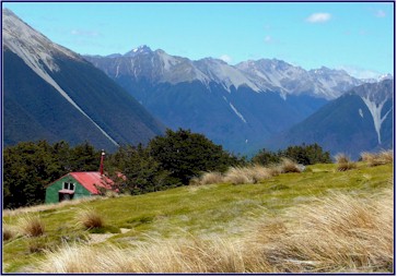
Our goal was to make it to the camping hut at the top of the
mountain ridge before heading back down.
As we
huffed and puffed up the track, and stopped to rest, an extremely
lean and fit looking man came jogging - yes, JOGGING!! - up the
trail, right where the switchbacks were the steepest. Damn!
He wasn�t even breathing hard.
Jineen considered sticking out her foot and tripping him as
he ran by, but at the last minute she masterfully restrained
herself.
At
some point on the climb, Jineen lost her sunglasses.
Later on, when she realized they were missing, she thought
she must have put them down somewhere when we stopped to rest; my
personal theory was that the mountain god took them as retribution
for her uncharitable thoughts about the jogger.
When we reached the top, we came out from the trees and
climbed above the timberline, and it was amazing.
We felt a great sense of accomplishment at having made it to
the top, but also a real high, which infused us with a new burst of
energy. We decided that
rather than turning back, we would keep going and do the whole loop
trail, about a five hour tramp (NZ for hike).
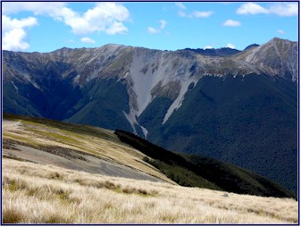
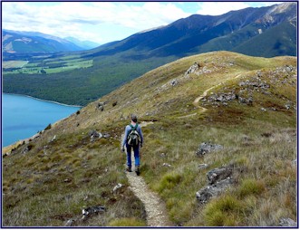
The path traversed along the top of the ridge, and the
scenery was spectacular. On
one side the mountain sloped upwards to a higher peak, but
everything else was below us. On
our way up, the higher we had climbed, of course, the further we
could see. But now, the
vistas that opened up in all directions were incredible.
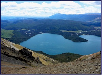
We felt like we could see forever. The
turquoise blue waters of
Lake
Rotoiti
were far below us, and the grandeur of the mountains behind it was
breathtaking.
(I
apologize for the excessive and redundant use of superlatives.
Words like beautiful, fabulous, magnificent, and incredible
keep being used over and over, because
New Zealand
simply IS all of those things, and it is hard to describe it without
repeatedly using them!)
We sat near the top with the world at our feet.
We snacked on trail mix and Snickers bars.
The birds were singing, the wind was blowing through the
trees, and we could hear no other sounds.
Time seemed to both stand still and to fly.
We
continued on, following the path that wound along the ridge.
The air was much cooler up at the top, and the wind was
strong. At one point the
trail crossed a narrow saddle where the ground fell steeply away on
either side; as we came to this point the wind hit us like an icy
blast. The temperature
felt like it dropped twenty degrees in a matter of seconds, and I
was scrambling to get that long-sleeved shirt out of my pack � the
one I thought at lower altitudes that I wouldn�t need.
We
headed back by way of Paddy�s Walk.
This was the longer route, and the trail was rougher and
rocker. It wound back
and forth across the high open spaces, crossing the mossy
tundra-like terrain, and we could see it snaking down across the
open mountainside before us. Following
it, we crossed rocky scree-slides and streams with miniature
waterfalls. Presently we
returned to the forest.
In one of the watercourses, we saw large cloven hoofprints.
Were they made by deer? Chamois?
Thar? Pigs? In
the absence of evidence of any of the former three, we joked, we
were forced to conclude that the wild pigs we had seen early that
morning were stalking us.
We
traversed the lower section of the mountain, not far above the
shore
of
Lake
Rotoiti. We got back to
the carpark four and a half hours after we had left it, exhausted
but exhilarated. We
stopped at the side of the lake to view
Mt.
Robert
from below; we were really impressed by how far we had climbed.
While standing by
Lake
Rotoiti
enjoying the scenery, we glanced down and saw something moving in
the water. There were
giant eels living in the lake! They
were three to four feet long and as big around as your arm, and they
hung out under the small pier we were standing on.
There was a sign prohibiting fishing for eels, but they would
come to the surface to eat when we threw out breadcrumbs.
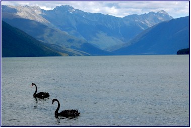
Back in the car, we continued on to
Lake
Rotorua
, also in Nelson�s
Lakes
National Park
. We had happy hour
there; another scenic spot with lovely mountains behind the lake and
black swans floating in front of us.
We enjoyed crackers with cheese and chutney, and finished off
the last of the
Cloudy
Bay
.
We headed for Murchison, where we planned to find lodging for
the night. Rather than
follow the main road, we found a tiny byway that wound its way back
and forth along a small river. Yellow
blossoming broom shrubs grew abundantly along the edges of the
stream, making a bright contrast to the deep green of the mountains.
The road went ever downward, as we had crossed the
�continental divide,� and we were now following the river west,
down towards the
Tasman Sea
.
We
drove through the
Mangles
Valley
. The road became very
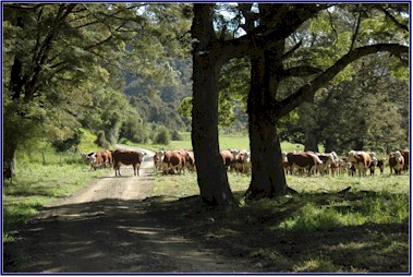
narrow and winding, crossing streams with open fords.
We saw a sign that said �Stock in Road,� and sure enough,
we rounded a bend and found a herd of
Hereford
cows blocking the way. We
politely requested that they move, and they graciously consented to
let us by.
When we arrived in Murchison, we started looking for a place
to stay. We had been a
little worried that it might not be easy to find lodging at the spur
of the moment; when we came in 2004 it had been in November, and a
few times it was hard to find a room.
Being a month later in the year and that much closer to the
peak season, we expected that it might be more difficult this time;
but to the contrary, so far it had proved less crowded than two
years ago. After
checking several different possibilities, we found a lovely farmstay
called Silverstone B&B, where we had our own little cabin with
views of the surrounding mountains.
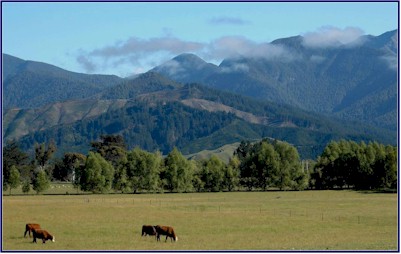
We watched the farmer move cattle and run his dogs.
Sheep were grazing outside our window.
We had dinner at the Rivers Caf� in town; then it was back
to Silverstone for a good night�s sleep.
Day
4
It was another beautiful day.
We left our room early and headed into town to use the
payphone to call home � only to find that you can no longer reach
an AT&T operator from a payphone in NZ.
Therefore unable to use our prepaid International calling
card, we went back to the Silverstone B&B and begged; our hosts,
Alf and Phyllis Kinzett kindly allowed us to use their personal
phone.
While
we were making the calls, we chatted with them about the farm.
We learned that in addition to sheep and cattle they raise a
large number of
red deer
. The stags grow an
enormous rack of antlers, and the Kinzetts raise them for the velvet
on these antlers. It is
sold to the Koreans, who use it in medicines and as an aphrodisiac.
To harvest the velvet, they sedate the male deer and saw off
their antlers. The deer
shed their antlers each year anyway, and they grow an entire new set
in 63 days!
Like
most NZ farmers, the Kinzetts have dogs to work the livestock.
But they also have �pig dogs,� used to hunt the wild
pigs. They told us that
the wild pigs have gotten quite numerous; they damage crops and
destroy the habitat of native birdlife, so they are considered a
pest and commonly hunted to control the population.
They told us rather lurid stories of tracking the pigs down
with the dogs and then killing them with a knife.
We
learned that Phyllis Kinzett�s sister Kate lived nearby, and that
she is a former Event Rider who raises horses.
We arranged to visit her breeding farm.
We
took a short drive back up the
Mangle
Valley
. Being a little early
for our appointment, we explored the back roads for a while; never
miss a chance to see what�s around the next corner.
Then we went to Tiraumea Farm, where we met Kate Kinzett.
She had enjoyed a successful Eventing career (highlighted by
being short-listed for the 1988 Seoul Olympics) and is now breeding
horses for Eventing, showing and foxhunting.
She showed us her two lovely crossbred stallions, Ironman and
Flint
, and also her youngstock. The
mares and foals grazed in green meadows surrounded by majestic
mountains.
Leaving Murchison and heading west, we passed through the
Upper Buller Gorge. This
had been hyped in the guidebooks as something not to miss, but we
found it disappointing. Was
there a gorge here? You
would never know it from the road.
The river was quite a ways below the highway, but with the
trees lining it, the views were few and far between.
Apparently you had to experience the gorge in a raft or kayak
to appreciate it.
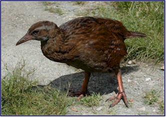
We
stopped at a scenic overlook picnic area for a rare view of the
river, and we were delighted to encounter a weka.
This is a chicken-sized flightless bird that is indigenous to
NZ; they are somewhat similar to a kiwi, but not nearly as rare.
This one had become quite tame; he obviously made his living
hanging out at the picnic area and begging scraps from tourists.
We fed him some bread crumbs, and he was very appreciative.
We continued on toward the west coast.
We kept planning to stop in the next town for a coke, but it
seemed that every �town� we passed consisted of something like
two houses close together and a mailbox, and no place where we could
so much as buy a soda.
Even the �main highways� in New Zealand are for the most
part fairly small roads, often very twisty where they go through
mountains, essentially what would be considered very small back
roads in the U.S. They
drive on the left, of course, and sometimes they drive amazingly
fast, even on the treacherous winding sections.
As in the
U.S.
, broken lines on the road indicate where you are allowed to pass,
but the difference is that in NZ you seem to be allowed to pass
almost anywhere, including on tight curves and blind hills.
I made a habit of pulling over to let overtaking cars by as
soon as I saw them in my rearview mirror.
We
passed another Highway Department cryptic message; a sign with a
picture of a car speedometer, with all of the numbers above 100
km/hr showing a dollar sign in front of them, representing the fines
for speeding. I could
identify with that one!
As we came closer to the west coast we saw a lot more dead
possums in the road: Jineen�s count made it 16 for the day, and
that was only counting the fresh ones!
We had learned about the possums when we visited NZ in 2004.
There are no native land mammals in
New Zealand
, which is one of the reasons there is such a rich and abundant
variety of bird life. Because
they had no natural predators, many flightless birds evolved, such
as the kiwi, the national symbol of NZ.
But the British will have their sport, and when they
colonized the country they imported animals for hunting and
trapping, and introduced them into the wild.
Unfortunately, many of these introduced species have had
devastating effects on the natural balance in NZ, destroying the
habitats and food sources of the native birds, and raiding their
nests.
The
Australian Possums, imported for their fur, have probably been the
worst culprits. In their
native country the environment naturally limits their population,
but they thrive on the climate and food sources in NZ, and they have
multiplied out of hand. It
is now estimated that over 90 million possums inhabit the country,
and they have decimated the populations of many birds, including the
kiwi, now endangered, and fighting extinction in the wild.
So
numerous are the possums that you can hardly drive a couple of
kilometers without seeing the remains of one that was hit on the
road. This is partially
because the NZ people, considering them dangerous pests, try to run
them down at any opportunity. We
had seen many dead possums along the way, but we had never seen a
live one.
We followed the turquoise river, going steadily downhill.
The Lower Buller Gorge had better scenery than the Upper, and
the road was more interesting. At
one point we came to a spot where the road was hewn into the side of
a cliff. There was only
one lane, with a sheer rock face on one side and a drop into the
river on the other. But
the disconcerting thing was that when you started through the single
lane cut into the cliff, there was no way to tell if another car was
coming from the opposite direction!
Further on there was another tricky spot; a one lane bridge
off a hairpin turn, with a mirror posted to check around the blind
corner for oncoming traffic. And
this was the main road!
A
billboard along the highway showed a photo of a corpse�s foot with
a morgue-type toe tag, and a caption which read �Speeding
Ticket.� We found this
one quite morbid; but then again maybe that was the point.
We came to the west coast, and the town of
Westport
. The coastline was
rugged, with large rock formations extending out into the sea, and
many small rough islands just off shore.
The road was twisty and winding; we followed it south, with
the mountains on our left and the
Tasman Sea
on our right. Hairpin
turns doubled back and forth as we climbed up over the shoulders of
the mountains, and then dropped sharply back down toward the ocean.
The water was a beautiful blue-green color in the sunlight,
with the breakers crashing against the shore.
We passed a caution sign for a penguin crossing; you don�t
see that every day!
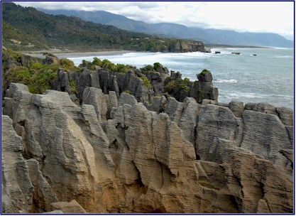
Presently we came to the
Paparoa
National Park
, and to the town of
Punakaiki
, where we visited the Pancake Rocks.
This is an area of the shore where the rocky limestone cliffs
have eroded into layers, like vast stacks of pancakes.
There are many strange formations, and at high tide, the
water comes crashing up through a number of blowholes.
It is a popular attraction, something we usually try to avoid
in favor of our �road less traveled� policy, and we were a
little worried that it might be crowded.
But we were pleasantly surprised to find that there were not
too many people around; we had gradually come to realize that
traveling just before Christmas was a great way to avoid the crowds.
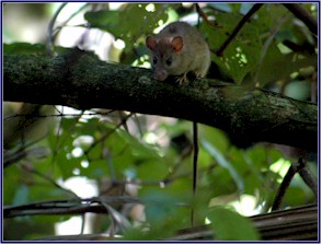
We
followed a path through the sub-tropical undergrowth, watching for
flowers and birds. We
saw several large rats among the bushes; more of
New Zealand
�s imported pests. The
path then wound along the shoreline and the cliffs, with many
overlooks where you could view the rock formations.
We saw the Pancake Rocks from different angles and
viewpoints. It was quite
unique; the rocks were worn into marvelous shapes, layer upon thin
layer forming the cliffs. A
colony of gannets nested on a rocky island just out from one of the
overlooks. The surf came
crashing in, filling the surge pools and spouting through the
blowholes. It was quite
an impressive sight.
We met a pushy guy from
Australia
who was taking photographs; he offered us much unsolicited advice on
photography. He was a
pilot for FedEx, and he told us stories about transporting the
Melbourne Cup winner and his Asian owner.
He seemed to know a lot about photography.
And about flying, racing, traveling, gambling, and politics;
in fact, he seemed to be quite an expert on every subject that came
up. We were happy when
we eventually managed to escape him.
We went for a short walk on the Truman Track, a path that
started through the rainforest, thick with ferns, nikau palms and
rimu, and then came out into the open and led down to the sea.
The beach consisted of millions of tiny pebbles, on their way
to becoming sand, washed perfectly round by the sea.
It was extremely difficult to walk on this footing; our feet
sunk in and slid backwards with every step.
It felt like one of those dreams where you are trying to run
but you can�t, and everything is in slow motion.
We found that we could walk better if we went right down to
the waterline where the sand was wet, but then we were dodging the
waves of the incoming tide. We
wandered among the overhangs and shallow caves in the cliff face; it
was an exotic and alien-looking landscape of rock formations.
Next we hiked up the Pororari River Track.
It was a pleasant walk along the river, with cliffs rising up
on both sides � we considered it a better gorge than the
much-touted Buller. We
saw a pair of brightly colored Paradise Shelducks with three babies,
paddling along in the water. These
are attractive duck-like birds brilliantly marked in black, white,
chestnut and green; the females have a white head, and the males
have more black. We saw
several other Shelducks further upstream, and heard their loud and
distinctive call as they flew along the river.
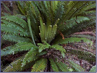
We collected some beautiful NZ ferns, which we intended to
smuggle home in our suitcases for my mother Grace; she makes amazing
wreathes out of dried plants and flowers, and we were willing to
risk fines and imprisonment to bring her the ferns she had
requested.
We
were lucky with the weather. The
day had started to cloud over and become gray while we were at
Punakaiki, but the rain held off. Then
just as we got in the car after our hike, it quite suddenly started
to pour. Perfect timing!
We arrived at Greymouth at dusk.
It is a very gloomy place; even in the guidebooks it has a
reputation of not having much to offer.
Why does it seem so dreary, we wondered?
Perhaps because we have never seen it when it wasn�t
raining! We had spent
the night there in 2004, and it had been raining then too.
For all we knew, it may never have stopped.
We
had no trouble finding a room; we checked in to the Sundowner Motel.
It was comfortable enough, but the d�cor was, well,
interesting. The walls
were cinderblock, painted lime green, and the carpet was blue and
orange striped. The
curtains were a different striped pattern, of blue, green, red and
yellow, and the bedspread was in plaid squares of all of the above
colors, plus pink. The
cabinets were brick red, and whoever had chosen the towels had
managed to somehow find hues that did not match any of the other
colors in the room. Considering
the decorator�s taste, it was just as well that there were no
pictures hanging on the walls. Perhaps
this kaleidoscope of colors was meant to counteract the dreary grey
of Greymouth. If so, it
had dubious results.
We
took a tour of the town, looking for Steamers, a restaurant that had
been recommended to us. We
had a little map, but there were no signs on most of the streets, so
we drove around the town center about four times in the pouring rain
searching. When we
finally found the restaurant, we had an excellent dinner; locally
caught fish for Jineen and roasted NZ lamb for me.
We
returned to the motel for a belated happy hour; we hadn�t done it
earlier because we had too much driving to do in the rain.
We finished off some Stoneleigh Chardonnay we had opened on
the first day (excellent) and sampled the St. Clair Chardonnay (not
so good). We sat in our
impeccably color-coordinated room, looking at guide books, planning
hikes, drinking wine and eating Anzac (acronym for Australian and
New Zealand Army Corps) cookies, what could be better?
Oh yes, it�s pouring. Can�t
have everything!
Day
5
It had rained all night; we had heard it beating down on the
roof really hard. The
forecast was for steady rain all day, but to our pleasant surprise
by morning it had stopped. Maybe
we had beaten the odds.
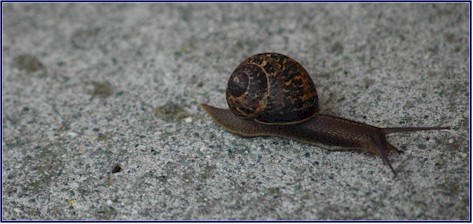
We had our first wildlife sighting of the day as we came out
of or motel room door � a snail!
I photographed it, commenting on what a novelty it was to not
have to hurry to get the shot � it wasn�t moving very fast.
We went to the supermarket to stock up on happy hour
supplies, and to put petrol in the car.
On the
South Island
you never want to let your tank get down past halfway, as the gas
stations are few and far between.
Our
general plan for the overall route on this trip was to roughly
circumnavigate the
South Island
in a counterclockwise direction.
On our previous visit we had made a circuit of the central
portion of the island; this time we were going much further both
north and south, and mostly visiting areas that we had not seen on
our first trip. However
there is only one road down the west coast, so it was unavoidable
that here we would be following some of the same route we had taken
before. Not that we
minded, because it was a spectacularly beautiful area.
And there is so much to see and do that you can�t possibly
do it all anyway, so even though we were driving some of the same
highway, we were stopping and exploring in very different places.
We
were heading south on Highway 6, the west coast road.
At times the road was quite straight and fast, and in other
places it was convoluted and twisty, weaving its way up and down
over the lower reaches of the mountains.
The highway was quite empty, and we hardly passed another
car.
We
had crossed over many narrow one-lane bridges in our travels through
New Zealand
; most of the bridges were built this way.
But here something was different - we also had to share with
the railroad! The sign
said �Give way to trains.� You
think?!? It definitely
seemed the obvious choice. But
these one lane bridges were long and narrow, and you couldn�t
really see to the far end to know if a car was coming, much less a
train. What were you
supposed to do if you were on the bridge and a train was
coming? Back up really
fast?
I
just love the graphic road signs in NZ.
There was one showing a picture of a bicycle wrecking on a
bridge, hitting a bump and sending the rider flying.
We
continued on the road, looking for a place to access the beach.
We turned down several small lanes that turned out not to go
to the shore, but we saw some interesting sights nonetheless.
We passed a pasture of cows wearing rugs.
Some of them also had banged tails.
Were they Show cows? Event
cows? Learner cows?
(I started my riding career on a cow.)
Or just wimpy cows? Our
imaginations ran wild.
We
passed through the town of
Ross
; I recognized this as where I got my speeding ticket on the last
visit. Despite never
paying it I wasn�t in jail yet, so that was a good sign.
I drove slowly.
We pulled out the map and looked for the smallest
�yellow� back roads we could find � we like to get off the
beaten path and see a side of
New Zealand
that most visitors never see. We
turned on to
Bold Head Road
, a four wheel drive track. It
was a very small unsealed road that went through farmland, and then
along the coast through the Kakapotaki Ecological Reserve.
We saw a great variety of birdlife on this small road.
Jineen got out her NZ bird book, and we identified, among
others, spur winged plover, pied oyster catchers and chaffinches. The
distinctively colored Paradise Shelducks inhabited the small ponds
and marshy areas, and falcons flew along the roadside.
We
saw pukekos everywhere; these chicken-like blue and black birds are
very prevalent in low-lying wet areas.
I wondered if people hunted them much for food; I understand
they can be rather tough. I
read a book before the trip with a recipe for cooking pukeko:
Fill a pot with water, add salt and spices to taste, and put
an axe (the metal part only) into the pot.
Bring the water to a boil, and then add the pukeko bird.
Continue to boil until the axe becomes soft, then throw out
the bird and eat the axe.
Having
seen virtually no vehicles on the main road since leaving Greymouth,
in about 10 kilometers on this tiny lane we met a school bus, two
farm trucks, a road grader and a huge dump truck.
The last was almost our undoing, as the shoulder of the road
was much softer than it looked.
As we pulled off to let the truck by we sank almost to our
axles, but fortunately our intrepid little 4WD Honda saved us by
managing to crawl back onto the road, amid much wheel spinning.
Our little road presently rejoined Highway 6, and we
continued south.
~ continued ~
|